WHEN GORDON BARNES joined the U.S. Air Force in 1956, he worked as a navigator on the tanker planes that refuel long-range bombers in midair. Coordinating a connection between two planes moving hundreds of miles an hour at 30,000 feet may sound exciting, but Barnes found the work routine. “It actually did get boring to me,” he says.
A few years later, he stumbled into a line of work he liked much better. The Air Force sent him back to school to get a master’s degree in geodesy—the science of defining the Earth’s size and shape and the fluctuations in its gravitational field.
At first, Barnes barely knew what geodesy was. But it grew on him. “It stimulated my mind like nothing I’d done before,” he says. “The more you get into it, the more fascinating it is.”
When he returned to the Air Force after graduate school, Barnes was assigned to the 1370th Photo Mapping Wing—the unit profiled in the video above. The documentary was made in 1961, a few years before Barnes joined the wing. It’s 25 minutes of retro awesomeness.

The work of the 1370th bridged a crucial gap in the history of military technology. By the late 1950s, both the United States and the Soviet Union had developed intercontinental ballistic missiles, but satellite navigation systems like GPS weren’t yet up and running. That left military planners with a huge challenge: how to program a missile to hit a target on the other side of the world. Even a tiny mistake could be disastrous.
The maps of the time weren’t up to the task. That’s where geodesy came in.
By the mid-20th century, the landmasses of Europe, North America, and parts of Asia had been carefully mapped by teams of surveyors working their way across the ground. But because that approach doesn’t work on the open ocean, each continent remained isolated—there was no single geodetic network to link them together.
In practical terms, that meant that while the exact distance between Paris and Rome was known, the exact distance between Paris and New York—or more to the point, between a missile silo in South Dakota and the Kremlin—was not.

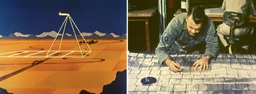
One goal of the 1370th was to create a worldwide geodetic system to connect the continents. Their main tool was something called HIRAN aerial geodetic surveying, which is nicely illustrated by a cartoon in the video (starting around the 3:55 mark). The method required setting up two ground stations at known positions and then flying a plane between them. Equipment on the plane sent out radio signals and measured the time it took them to bounce off the stations and back to the plane. After multiple flybys and some number crunching, this produced an accurate measure of the distances between the two stations.
A third ground station could then be added, its distance to the first two calculated, and so on, forming an ever-expanding network of triangles. Because each leg could be up to 500 miles long, the HIRAN method was great for making accurate measurements of distance over oceans, jungles, polar ice, and other large areas that couldn’t be surveyed by teams on the ground.
The 1370th Photo Mapping Wing, as its name implies, also did photo mapping. Pilots would fly in a straight line over an area while electronically timed cameras snapped a series of overlapping photos. These images could later be stitched together and brought into register with precise position data from land (and/or HIRAN) surveys to make accurate, highly detailed maps. The Army used these maps for military planning. Foreign governments often requested the services of the 1370th as well, to make maps that could be used to settle border disputes, plan road networks, or pursue natural resources.
Barnes was in charge of planning and reconnaissance for these mapping missions. One of them was a major operation in Ethiopia in the mid-1960s.
“First we had to decide where to put the HIRAN stations,” he says. “[The goal was] to use the fewest of them we possibly could to get the country mapped. You want them on the highest peaks to get the longest electronic line of sight.”
Then, a team would go visit those sites to figure out what equipment they’d need to set up the stations, and how they’d supply the men who’d operate them. In a vastly undeveloped country, the logistics weren’t trivial. “You might as well have been on the moon for most of it,” Barnes says.
Once Barnes came up with a plan, he’d hand it off to one of the ground-station squadrons and one of the flying squadrons of the 1370th. They, in turn, would set up the ground stations and begin flying the surveying and mapping routes. In the case of Ethiopia, that took about five years.
Barnes visited a few times to check on the progress, but he says the guys who manned the ground stations had the real adventures. In addition to hazards like high altitudes and blazing desert heat, they encountered roaming bandits, voracious insects, wild dogs, elephants, and poisonous snakes. Once, locals blamed the foreign airmen and their strange equipment for a tornado that destroyed several grass huts in their village, which sat at the foot of a mountaintop being used as a ground station.
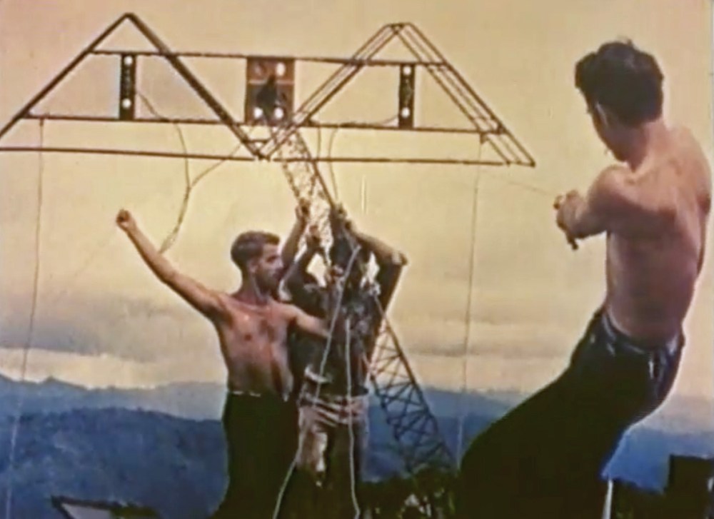
Another time, a crew set up a ground station on a mountaintop that turned out to be the home of a large troop of baboons. One day the animals attacked, throwing sticks and rocks, screaming and baring their fangs. The men radioed for help. One of the planes flying a photo-mapping mission buzzed the mountaintop a few times, after which the baboons ran off into the forest.
Eventually, satellites made all of this work obsolete. The 1370th Photo Mapping Wing was renamed the Aerospace Cartographic and Geodetic Service in 1967 and deactivated in 1975.
Barnes, who’s now 82, embraces the technology that made his old job obsolete. He’s gotten into geocaching—the treasure-hunting game where people use GPS receivers to find little caches of stuff other people have hidden in out-of-the-way places. It never ceases to amaze him that he can type the coordinates into a handheld device that costs less than $100 and get within a few feet of what he’s looking for.
As he says, “What it used to take to do that, like in Ethiopia, is just mind-boggling.”
This article was originally published on our blog All Over the Map at National Geographic.
